Disclaimer: Views in this blog do not promote, and are not directly connected to any L&G product or service. Views are from a range of L&G investment professionals, may be specific to an author’s particular investment region or desk, and do not necessarily reflect the views of L&G. For investment professionals only.

An El Niño is the warm phase of the El Niño – Southern Oscillation, a natural climate pattern in which sea surface temperatures in the central and eastern tropical Pacific rise above average. Those changes can alter global weather patterns, influencing rainfall, temperature and storm activity well beyond the Pacific itself.
This blog explores the effects of this year’s forecast El Niño on the 2026 hurricane season on insurance-linked securities.
Current Climate Prediction Center (CPC) forecasts suggest that El Niño is likely to emerge soon and continue through the second half of 2026. The Climate Prediction Center stated in its recent update that there is an 82% chance of El Niño developing in May–July 2026 and a 96% chance that it persists into winter 2026–27.
The chart below shows the Oceanic Niño Index (ONI), with the forecast path highlighted in orange. Readings above +0.5°C indicate El Niño conditions, while readings below -0.5°C indicate La Niña conditions. For an event to be formally classified, the threshold normally needs to persist for five consecutive overlapping three-month periods. The CPC forecasts in orange show that this is likely to be a severe El Niño year.
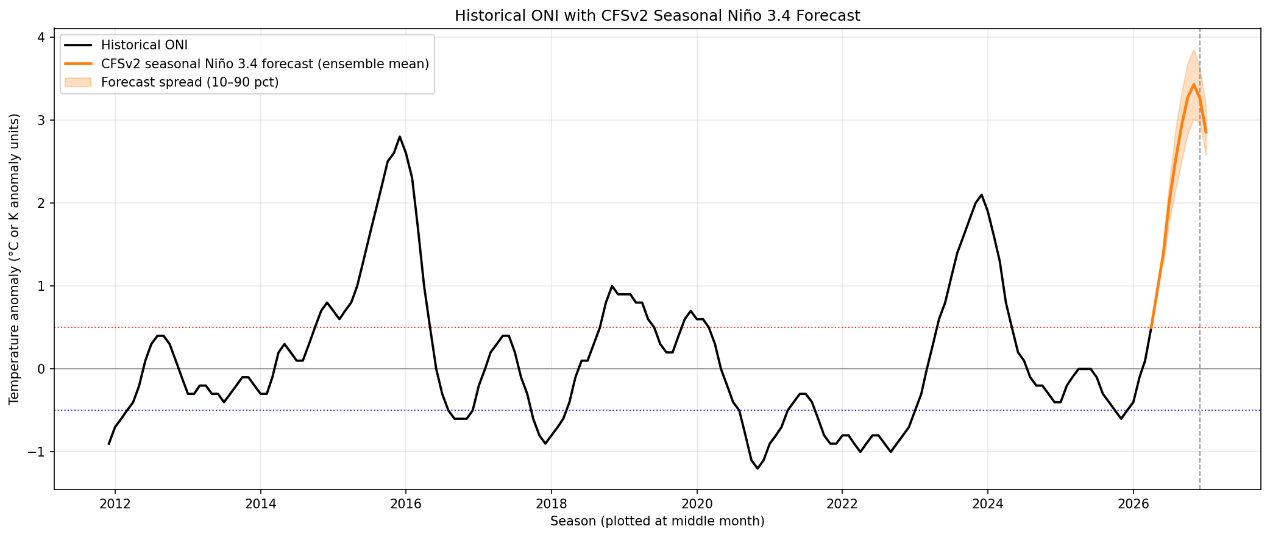
Sources: https://www.cpc.ncep.noaa.gov/products/analysis_monitoring/ensostuff/ONI_v5.php and https://www.cpc.ncep.noaa.gov/products/CFSv2/dataInd1
As insurance-linked security investors, we must consider what this means for Atlantic hurricanes. El Niño typically increases vertical wind shear over the tropical Atlantic, which can disrupt cyclone formation and limit storm intensification. Broadly speaking, that tends to make the basin less supportive of a very active hurricane season.
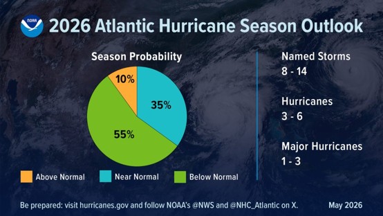
That relationship is reflected in the National Oceanic and Atmospheric Administration’s (NOAA) 2026 outlook, which assigns a 55% probability to a below-normal Atlantic hurricane season. The agency currently forecasts 8–14 named storms, 3–6 hurricanes and 1–3 major hurricanes, compared with a ten-year average of 18 named storms, 8 hurricanes and 4 major hurricanes.
Source: https://www.aoml.noaa.gov/how-does-el-nino-impact-atlantic-hurricane-season/
That said, a quieter basin does not remove risk entirely. Seasonal forecasts describe overall activity, not where storms will travel or where losses may occur. Even in a below-normal year, a single storm making landfall in a heavily populated area can still generate significant insured losses.
Historical El Niño periods provide useful context, even if each season has its own drivers. The two previous major El Niño years were in 2015 and 2023. In the chart below we have mapped the hurricanes that formed during these two years. The relationship is not mechanical, but past El Niño years have often been associated with less supportive Atlantic conditions, and we can see that few made landfall in the continental US.
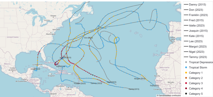
Generated using the L&G Alicat application, open street map, and NOAA NHC HURDAT2 — North Atlantic hurricane best-track database (National Oceanic and Atmospheric Administration, National Hurricane Center). Intensity categories follow the Saffir–Simpson Hurricane Wind Scale
At L&G, this backdrop reinforces the importance of disciplined catastrophe risk management rather than complacency. We continue to monitor seasonal forecasts, storm development and changes in climate indicators such as ENSO, while maintaining a diversified catastrophe risk portfolio designed to be resilient across a range of potential outcomes. In practice, that means staying alert to both the headline expectation of a milder season and the residual tail risk that always remains in hurricane markets.
Sources:
https://www.artemis.bm/2026-atlantic-hurricane-season/
CFSv2 Seasonal Climate Forecasts
Additional CFSv2 SST forecasts
https://www.cpc.ncep.noaa.gov/products/analysis_monitoring

Recommended content for you
Learn more about our business
We are one of the world's largest asset managers, with capabilities across asset classes to meet our clients' objectives and a longstanding commitment to responsible investing.